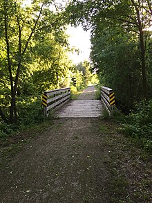
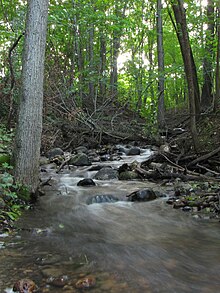
A place to be in awe. The Duck Creek Trail in Wisconsin is a crushed limestone trail in Outagamie and Brown Counties in northeast Wisconsin. The Duck Creek Trail spans seven miles, beginning at the eastern end of the Newton Blackmour State Trail, just east of Vanderheuvel Road in Seymour. The trail continues east through the Oneida Nation of Wisconsin in northern Outagamie County paralleling State Route 54, and continues to the Village of Oneida. The Duck Creek Trail will eventually extend to Pamperin Park in Green Bay.
With the connection to the Newton Blackmour State Trail, the combined trails are over 30 miles (48 km) long. The combined trails extend from Village of Oneida to New London. (wiki)
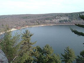
Located in Devil’s Lake State Park is a state park located in the Baraboo Range in eastern Sauk County, just south of Baraboo, Wisconsin. Devil’s Lake State Park is the largest state park in Wisconsin. It lies on the western edge of the last ice-sheet deposited during the Wisconsin glaciation and is known for its 500-foot-high quartzite bluffs along the 360-acre Devil’s Lake, which was created by a glacier depositing terminal moraines that plugged the north and south ends of the gap in the bluffs during the last ice age approximately 12,000 years ago. The sand at the bottom of Devil’s Lake is thought to be deposited by glaciers.
Parfrey’s Glen, Wisconsin’s first state natural area, is managed by the Devil’s Lake State Park and located just east of the park.
History
The area where the park now stands was first settled by pioneers in the mid-1800s. By the start of the 20th century, the area had become a popular vacation destination for wealthy families from Chicago and Madison. The first hotel was established in 1866, 50 years before the park was founded.
The park was founded in 1911. It was home to five resorts, two of which were perched on the west bluff. No trace of any of these hotels remains. There were also many private residences in the west and south shores of the lake, only four of which remain. At various times the lakeshore hosted water slides, lodges, and golf courses. The clubhouse of one course sat on the current location of the park’s nature center. By the 1940s, the hotels were all closed, and the park was retreating to its former natural self.
In 1974, the National Park Service declared the Southern portion of the Baraboo Hills a National Natural Landmark. The Nature Conservancy also designated it as one of the Last Great Places; it is one of only 77 of these places in the world.
GEOLOGY
Loess covers most of the hills and forms the parent material of a brown silt loam soil. The lake is surrounded by a mixed conifer-deciduous forest and the Baraboo Hills are also home to one of the largest contiguous hardwood forests in the Midwest.
North Glacial Moraine is well covered by the north shore developments. The parking lots, concession building and the picnic shelter all sit atop the moraine. This moraine forms the northern border of Devil’s Lake. The moraine is approximately 80 feet.
Southeast Glacial Moraine is located between the East Bluff-South Face and the South Bluff. The Group Camp is located atop the moraine. It is best seen from the Roznos Meadow parking area along State Route 113. The moraine is approximately 130 feet (40 m) thick.
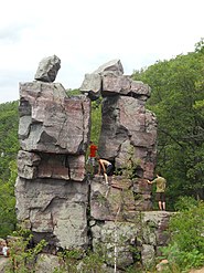
Due to the long geological history of Devil’s Lake and the Baraboo Range, the area has been used in geological research for years. The lake itself is rectangular in shape and is a little over a mile long from north to south and a half mile from east to west. It has many cliffs, unique rock formations and a variety of animal and plant species. One of the most notable features of the park is the presence of large talus slopes on three sides of the lake.
Nature center
The exhibits at the park’s nature center focus on the geology and natural history of the area. Public nature programs are offered in the summer, as well as evening programs on Saturday nights in the Northern Lights Amphitheater. The nature center also has many historical photographs that come from as far back as the 1800s. They also have many displays of examples of the flora and fauna that can be found throughout the park.[2]
Looking for some of the most scenic trails around Michigan. Copper Harbor is your spot. It is an all-season resort town in northeastern Keweenaw County, Michigan located on the Keweenaw Peninsula which juts out from the Upper Peninsula of Michigan into Lake Superior. Due to its natural environment and surroundings it is a popular tourist destination within the Great Lakes region.
One popular spot for visitors is Hunter’s Island which is the name of a non-hilly point running out from the west into Lake Superior. It was named for an early settler of the area named Mr. Hunter who owned a tract of land on what is now Hunter’s Point or Hunter’s Island. Situated at the opening of the harbor itself is the historic Copper Harbor Lighthouse built in 1866, replacing an earlier lighthouse made in 1849. It is only accessible via a short ride in a compact open vessel from the Copper Harbor marina. Exhibits inside the lighthouse museum cover both the lighthouse history along with the local shipwreck culture of the area.
Another popular site known as “the most beautiful road in Michigan” is the Brockway Mountain Drive that is an 8.8 mile route that follows the backbone of a 753-foot-high ridge between the towns of Copper Harbor and Eagle Harbor and is the highest paved road between the Rocky Mountains to the west and the Allegheny Mountains to the east. Constructed during the 30’s, this very picturesque road offers stunning views of Lake Superior and Keweenaw Penisula as well as the archipelago of Isle Royale.
wiki
<a href="http://<iframe style="width:120px;height:240px;" marginwidth="0" marginheight="0" scrolling="no" frameborder="0" src="//ws-na.amazon-adsystem.com/widgets/q?ServiceVersion=20070822&OneJS=1&Operation=GetAdHtml&MarketPlace=US&source=ac&ref=tf_til&ad_type=product_link&tracking_id=karlarachfal-20&marketplace=amazon®ion=US&placement=1250230845&asins=1250230845&linkId=7233ebdb499fcea04a6bf717dd3da322&show_border=false&link_opens_in_new_window=false&price_color=333333&title_color=0066c0&bg_color=ffffff"> Outdoor School Hiking and Camping
You can’t find a more tranquil place than here. The Hartman Reserve Nature Center is located in Cedar Falls, Iowa and is approximately 309 acres large. It is the largest undisturbed wooded area in Black Hawk County, Iowa and is home to three distinct habitats including wetland, forest and prairie. The reserve is dedicated to teaching youth about nature through hands on experiences and preservation.
Hartman Reserve was named after John C. Hartman who was the editor for the Waterloo Daily Courier who also was a nature enthusiast and amateur archaeologist.
When the YMCA could not raise the money to buy the property, Hartman donated a sizable amount towards the purchase which was enough to have the property bear his name. Hartman Reserve is home to many trails which include paved, unpaved and water trails. There are over 6 miles worth of walking trails with the most notorious of these trails being the American Discovery Trail. All of the water trails lead into the Cedar River, the George With Memorial State Park and the many lakes on the reserve. The walking trails are dispersed throughout the reserve with varying levels of difficulty. During the Winter, snowshoe trails are available that replace the regular walking trails that can be used anyday between sunrise and sunset.
This amazing trail connects to the larger and more well known American Discovery Trail which is a system of recreational trails and roads that collectively form a coast-to-coast hiking and biking trail across the mid-tier of the United States. Horses can also be riddenon most of this trail which starts on the Delmarva Peninsula on the Atlantic Ocean and ends on the northern California coast on the Pacific Ocean making it a total length of 6,804 miles long. (wiki)
The every popular Western Meadowlark. The western meadowlark has distinctive calls described as watery or flute-like, which distinguish it from the closely related eastern meadowlark. The western meadowlark is the state bird of six states: Montana, Kansas, Nebraska, North Dakota, Oregon, and Wyoming.
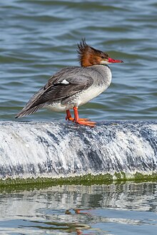
The Hooded and Common Merganser. In most places, the common merganser is as much a frequenter of salt water as fresh water. In larger streams and rivers, they float down with the stream for a few miles, and either fly back again or more commonly fish their way back, diving incessantly the whole way. In smaller streams, they are present in pairs or smaller groups, and they float down, twisting round and round in the rapids, or fishing vigorously in a deep pool near the foot of a waterfall or rapid. When floating leisurely, they position themselves in water similar to ducks, but they also swim deep in water like cormorants, especially when swimming upstream. They often sit on a rock in the middle of the water, similar to cormorants, often half-opening their wings to the sun. To rise from water, they flap along the surface for many yards. Once they are airborne, the flight is strong and rapid. They often fish in a group forming a semicircle and driving the fish into shallow water, where they are captured easily. Their ordinary voice is a low, harsh croak, but during the breeding season, they (including the young) make a plaintive, soft whistle. Generally, they are wary, and one or more birds stay on sentry duty to warn the flock of approaching danger. When disturbed, they often disgorge food before moving. Though they move clumsily on land, they resort to running when pressed, assuming a very upright position similar to penguins, and falling and stumbling frequently.
The Ruffed Grouse. Ruffed grouse have two distinct morphs: grey and brown. In the grey morph, the head, neck and back are grey-brown; the breast is light with barring. There is much white on the underside and flanks, and overall the birds have a variegated appearance; the throat is often distinctly lighter. The tail is essentially the same brownish grey, with regular barring and a broad black band near the end (“subterminal”). Brown-morph birds have tails of the same color and pattern, but the rest of the plumage is much more brown, giving the appearance of a more uniform bird with less light plumage below and a conspicuously grey tail. There are all sorts of intergrades between the most typical morphs; warmer and more humid conditions favor browner birds in general.
Displaying male
The ruffs are on the sides of the neck in both sexes. They also have a crest on top of their head, which sometimes lies flat. Both genders are similarly marked and sized, making them difficult to tell apart, even in hand. The female often has a broken subterminal tail band, while males tend to have unbroken tail bands, though the opposite of either can occur. Females may also do a display similar to the male. Another fairly accurate sign is that rump feathers with a single white dot indicate a female; rump feathers with more than one white dot indicate a male.
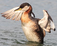
The red-necked grebe is a migratory aquatic bird found in the temperate regions of the northern hemisphere. Its wintering habitat is largely restricted to calm waters just beyond the waves around ocean coasts, although some birds may winter on large lakes. Grebes prefer shallow bodies of fresh water such as lakes, marshes or fish-ponds as breeding sites.
The red-necked grebe is a nondescript dusky-grey bird in winter. During the breeding season, it acquires the distinctive red neck plumage, black cap and contrasting pale grey face from which its name was derived. It also has an elaborate courtship display and a variety of loud mating calls. Once paired, it builds a nest from water plants on top of floating vegetation in a shallow lake or bog.
The barred owl, also known as northern barred owl or hoot owl, is a true owl native to eastern North America. Adults are large, and are brown to grey with barring on the chest. Barred owls have expanded their range to the west coast of North America, where they are considered invasive.
The common loon or great northern diver is a large member of the loon, or diver, family of birds. Breeding adults have a plumage that includes a broad black head and neck with a greenish, purplish, or bluish sheen, blackish or blackish-grey upperparts, and pure white underparts except some black on the undertail coverts and vent. Non-breeding adults are brownish with a dark neck and head marked with dark grey-brown. Their upperparts are dark brownish-grey with an unclear pattern of squares on the shoulders, and the underparts, lower face, chin, and throat are whitish. The sexes look alike, though males are significantly heavier than females.
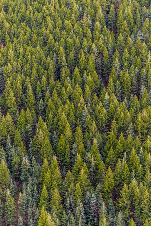
Looking for premier hiking in the Midwest. Look no furture….The Ice Age Trail is a National Scenic Trail located in Wisconsin. The trail is also one of 42 designated Wisconsin state trails and the only one specifically designated as a “State Scenic Trail.” From Interstate State Park on the Minnesota border to Potawatomi State Park on Lake Michigan, the Ice Age Trail winds for more than 1,000 miles, following the edge of the last continental glacier in Wisconsin.
One of only 11 National Scenic Trails, the Ice Age Trail is intended to be a premier hiking trail and conservation resource for silent sport and outdoor enthusiasts. The trail traverses some of Wisconsin’s most scenic landscapes and helps tell the story of the last Ice Age by highlighting Wisconsin’s unique glacial features.
Primary attractions include topography left by glaciation in the Last Ice Age. Glacial features along the trail include kettles, potholes, eskers, and glacial erratics. Many of the best examples of glacial features in Wisconsin are exhibited in units of the Ice Age National Scientific Reserve, most of which lie along the trail.
The Ice Age Trail is primarily an off-road hiking and backpacking trail that provides excellent opportunities for sightseeing, wildlife viewing and bird watching. In winter, some sections of the trail are open for cross-country skiing and snowshoeing.
CAMPING
Opportunities are available for camping along the Ice Age Trail in national, state and county forests and in many state and county parks, including some private campgrounds. Campgrounds can vary from primitive walk-in campsites to facilities complete with electric hookups. When planning a trip, it is best to check ahead of time for camping locations and availability. The Ice Age Trail Atlas and Guidebook, which are available for sale from the Ice Age Trail Alliance, provide camping and lodging details for all segments of the trail.
The Ice Age Trail travels through 30 counties on state, federal, county and private lands, connecting dozens of communities. There are hundreds of trailheads and access points located along the trail route. More than 600 miles of trail are open. The completed sections of the trail are connected by less-traveled roadways and other temporary routes.
Stone steps lead the way up the bluff trails at Devil’s Lake State Park.
The Ice Age Trail goes through several state and federal lands in Wisconsin, including traveling many miles through county and private lands. In addition to the state parks and forests listed below (from west to east along the trail), the Ice Age Trail travels through many state wildlife and fishery areas and some state natural areas.
Interstate State Park, Saint Croix Falls
Straight Lake State Park, near Frederic
Chippewa Moraine State Recreation Area, near New Auburn
Brunet Island State Park, Cornell
Chequamegon-Nicolet National Forest
Hartman Creek State Park, near Waupaca
Devil’s Lake State Park, near Baraboo
Kettle Moraine State Forest
Southern Unit, Eagle
Lapham Peak Unit, near Delafield
Loew Lake Unit, near Monches
Pike Lake Unit, near Hartford
Northern Unit, near Campbellsport
Point Beach State Forest, near Two Rivers
Potawatomi State Park, near Sturgeon Bay
The Ice Age Trail includes parts of other Wisconsin state trails.
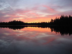
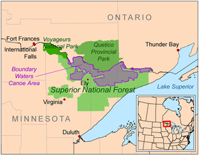
Think there is not much wilderness left in the United States…think again. And while much of it is in such states as California, Arizona, Washington and Alaska, we have a gem right here in the Midwest – Boundary Waters Canoe Area Wilderness in Minnesota!
Bordering the Arrowhead Region of the Canadian Board, the combined region of the BWCAW, Superior National Forest, Voyageurs National Park, and Ontario’s Quetico and La Verendrye Provincial Parks make up a large area of contiguous wilderness lakes and forests called the “Quetico-Superior country”, or simply the Boundary Waters. Lake Superior lies to the south and east of the Boundary Waters.
190,000 acres, nearly 20% of the BWCAW’s total area is water. Within the borders of the area are over 1,100 lakes and hundreds of miles of rivers and streams. Much of the other 80% of the area is forest. The BWCAW contains the largest remaining area of uncut forest in the eastern portion of the United States.
The Boundary Waters area is within the Laurentian Mixed Forest Province (commonly called the “North Woods”), a transitional zone between the boreal forest to the north and the temperate hardwood forest to the south that contains characteristics of each. Trees found within the wilderness area include conifers such as red pine, eastern white pine, birch, ash and even raspberries can be found in cleared areas.
The BWCAW contains a variety of hiking trails. Shorter hikes include the trail to Eagle Mountain (7 miles) Loop trails include the Pow Wow Trail, the Snowbank Trail, and the Sioux-Hustler Trail. The Border Route Trail and Kekekabic Trail are the two longest trails running through the BWCAW. The Border Route Trail runs east-west for over 65 miles through the eastern BWCAW, beginning at the northern end of the Superior Hiking Trail and following ridges and cliffs west until it connects with the Kekekabic Trail. The Kekekabic Trail continues for another 41 miles (66 km), beginning near the Gunflint Trail and passing through the center of the BWCAW before exiting it near Snowbank Lake. Both the Border Route and the Kekekabic Trail are part of the longer North Country National Scenic Trail.
Junction of the Eagle Mountain and Brule Lake Trails
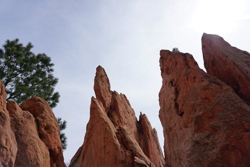
Looking for spectacular views with a short hike among some of the most unique rock formations in the United States? Look no further than Garden of the Gods in Southern Illinois. The most popular hike in the Shawnee National Forest, Garden of the Gods gives tourists amazing insight into the geologic structure of Southern Illinois and a view that stretches for miles high over the pristine hills of Shawnee Forest.
More than 320 million years ago, the wind and rain patiently started to chisel away at large deposits of sedimentary rock located in what is now, Shawnee National Forest . Over the years, the elements have sculpted some of the most stunning and extraordinary rock formations known to man. There are also plenty of trails for backpacking and horseback riding, allowing nature lovers a welcome tour of what the lively environment has to offer.
There are many miles of diverse hiking and backpacking trails in the Shawnee National Forest including the 160-mile River to River Trail.
One of the most photographed locations in the state, Garden of the Gods’ scenic beauty is extraordinary. In the recreation area you can hike, camp, nature watch or picnic.
The Observation Trail features unique sandstone rock formations and panoramic views of the surrounding Garden of the God Wilderness. Interpretive signs explain the geological history. The 1/4-mile trail is made of natural sandstone and takes about an hour to walk. It contains short, steep grades and steps; benches are located along the trail and as a whole the trail is not tiring. Caution should be used due to the high cliffs in the area.
Love sand and hiking on packed sandy paths? Indiana Dunes National Park, designated as the nation’s 61st national park is located in Northwestern Indiana along the southern shores of Lake Michigan. The park runs for nearly 25 miles alongside of Lake Michigan containing approximately 15,000 acres where you will find sand dunes, wetland, river, prairie and forest ecosystems. The Park is host to a wide variety of wildlife including white-tailed deer, red fox, raccoons, opossums, cottontail rabbits, various rodents, Canada geese, gulls, squirrels, hawks, turkey vultures , mallards, great blue herons, songbirds and garter snakes.
There are nine different diverse trails to explore!
* Paul H. Douglas Trail
* Tolleston Dune Trail
* Succession Trail.
* Bailly-Chellberg Trail.
* Little Calumet River Trail.
* Cowles Bog Trail.
* Calumet Dune Trail
* Glenwood Dune Horse and Hiking Trail
The Indiana Dunes has over 369 species of flowering plants of which thirteen are considered threatened or in danger of extinction. In addition, there are four invasive flowering plants on the list. Some of the more common spring flowers you will find include the May apple, 6 varieties of buttercups, and violets (14 types). During the Summer months orchids( 5 types) and lots of goldenrods (11 types) can be found.
For your first visit to the park, it is highly recommended that you visit the Dorothy Buell Memorial Visitor Center located at U.S. Route 20 and Indiana Route 49 near Porter, Indiana. The center offers standard visitor-center amenities including a video, brochures, hands-on exhibits and a gift shop. It is free to the general public.
If you like to camp…..check out the Dunewood Campground located on U.S. Route 12 which includes two loops of trailer accessible sites and a RV dump station. All sites have grills, a picnic table and access to restrooms with running water and showers. There are also a limited number of camp sites at the neighboring Douglas Loop. The park provides for 45 miles of hiking, fishing, swimming, horseback riding and cross-country skiing. Cycling is available on the Calumet Trail which is a crushed limestone multi-use trail that runs through the eastern section of the park. With all the things to see and do here, the park will draw over 2 million visitors each year.